



Österreich Wine Map – Austria Wine Regions
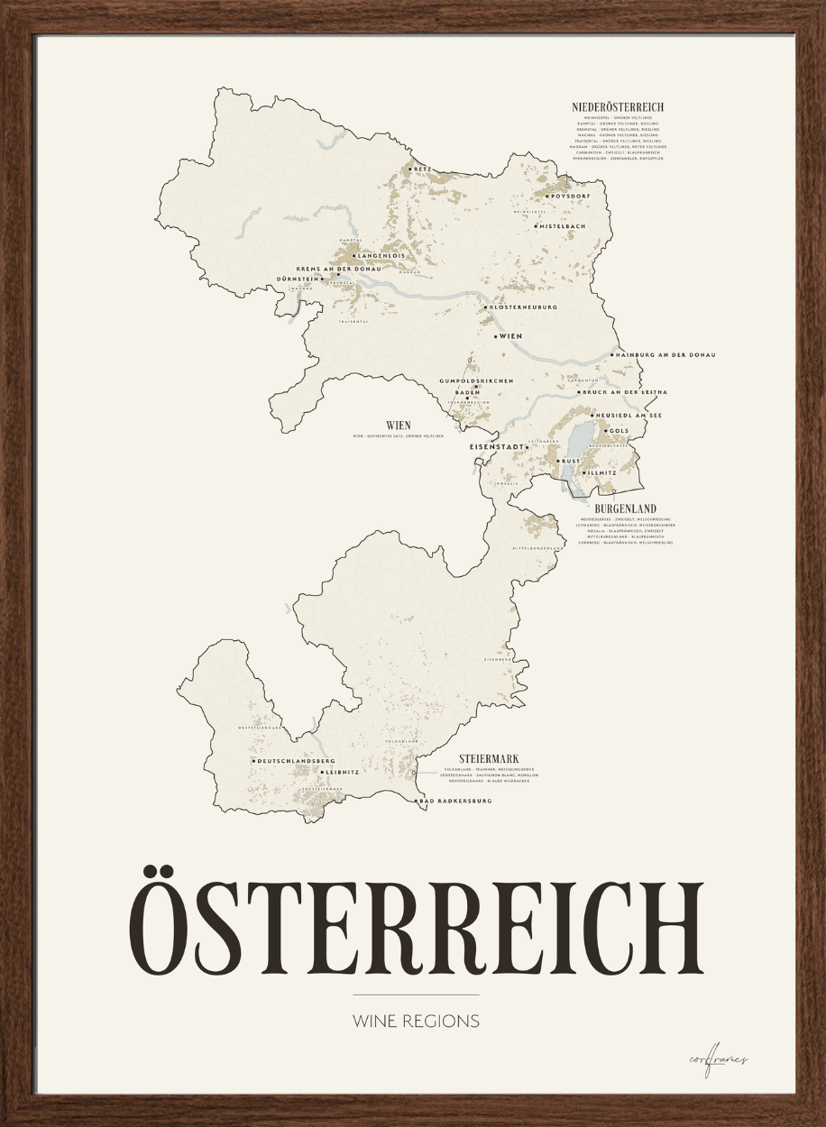
Discover Austria through a detailed wine map drawn from the vineyards themselves, plot by plot, from the terraced Danube slopes of the Wachau to the warm hills of Südsteiermark.
Austria is 570 kilometres wide, but almost all of its wine grows in the eastern fifth. Framed on the country, four fifths of a poster would be empty mountain. This map is framed on the vineyards instead — the 252 municipalities that carry ten hectares of vines or more, which is 98 % of the Austrian vineyard, in a frame of 215 by 244 kilometres.
Some 44,000 hectares are drawn plot by plot, so the vineyard appears where it really is: spread wide across the Weinviertel, tightly terraced above the Danube, wrapped around the shallow Neusiedler See, and scattered along the steep green ridges of Steiermark. Each of the four Weinbauregionen carries its own tinted ground, and every one of the seventeen Weinbaugebiete is named on its own vines, with the grapes it is known for.
Wien is the smallest of the four and the most unusual: the only major capital in the world with commercial vineyards inside the city itself, and the home of Wiener Gemischter Satz — a field blend of several varieties planted together, picked together and pressed together.
A decorative and informative wine map for anyone who wants to understand where Austrian wine actually comes from, and to add a refined piece of wine-inspired design to the wall.
The four Weinbauregionen
Austria is drawn as its four wine regions, each with its planted area and the Weinbaugebiete it holds:
- Niederösterreich – 26,732 ha · Weinviertel, Kamptal, Kremstal, Wachau, Traisental, Wagram, Carnuntum, Thermenregion
- Burgenland – 11,538 ha · Neusiedlersee, Leithaberg, Rosalia, Mittelburgenland, Eisenberg
- Steiermark – 5,109 ha · Vulkanland Steiermark, Südsteiermark, Weststeiermark
- Wien – 588 ha · Wien
The grapes on the map
Every Weinbaugebiet is named on the map together with the grapes it is known for:
- Weinviertel – Grüner Veltliner
- Kamptal – Grüner Veltliner, Riesling
- Kremstal – Grüner Veltliner, Riesling
- Wachau – Grüner Veltliner, Riesling
- Traisental – Grüner Veltliner, Riesling
- Wagram – Grüner Veltliner, Roter Veltliner
- Carnuntum – Zweigelt, Blaufränkisch
- Thermenregion – Zierfandler, Rotgipfler
- Neusiedlersee – Zweigelt, Welschriesling
- Leithaberg – Blaufränkisch, Weissburgunder
- Rosalia – Blaufränkisch, Zweigelt
- Mittelburgenland – Blaufränkisch
- Eisenberg – Blaufränkisch, Welschriesling
- Vulkanland Steiermark – Traminer, Weissburgunder
- Südsteiermark – Sauvignon Blanc, Morillon
- Weststeiermark – Blauer Wildbacher
- Wien – Gemischter Satz, Grüner Veltliner
Grüner Veltliner alone covers about a third of the Austrian vineyard. Zweigelt is the leading red, and Blaufränkisch gives Burgenland its reputation.
Details
- All four Weinbauregionen, each on its own tinted ground
- All seventeen Weinbaugebiete, named with their leading grapes
- The vineyard drawn plot by plot — some 44,000 hectares
- The Donau, Kamp, Leitha, Thaya, March and Mur, and the Neusiedler See
- Original Corkframes design
Material & print
Printed on eco-friendly FSC®-certified fine art paper, 200 gsm, with an uncoated soft matte finish that renders colour softly and naturally.
Sizes
Available in 30×40 cm, 50×70 cm and 70×100 cm.
Delivery
Delivered within 3–8 business days, anywhere in the world.
Framing
The poster ships unframed. It fits our art frames in oak, smoked oak, black and white.
More about the wine
Subscribe to our newsletter
Promotions, new products and sales. Directly to your inbox.