



Deutschland Wine Map – Germany Wine Regions
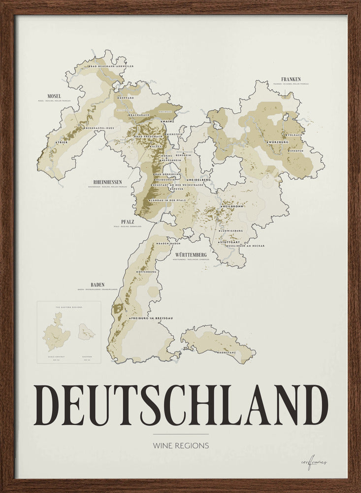
Discover Germany through a detailed wine map drawn from the vineyards themselves, plot by plot, from the slate terraces of the Mosel to the shores of the Bodensee.
German wine is a thread, not a blanket. It follows the Rhein and its tributaries and clings to the steep south-facing slopes where the grapes ripen. The map draws all of it — some 109,000 hectares — so the vineyard appears where it actually is: dense along the Mosel and across Rheinhessen, and thinning to a handful of hillsides in the Ahr and on the Bergstraße.
Behind the vineyards, each of the thirteen Anbaugebiete carries its own tinted ground, so you can see where Rheinhessen ends and Nahe begins. The six largest are named with their leading grapes: Riesling runs from the Mosel through Rheinhessen and the Rheingau, Spätburgunder holds Baden and the Ahr, Silvaner belongs to Franken and Trollinger to Württemberg.
Saale-Unstrut and Sachsen lie some 250 kilometres east of the rest, on the Saale, the Unstrut and the Elbe. They are drawn in their own panel, which lets the main map be shown at a size where the vineyard stays readable.
A decorative and informative wine map for anyone who wants to understand where German wine actually comes from, and to add a refined piece of wine-inspired design to the wall.
The thirteen Anbaugebiete
Germany is drawn as its thirteen wine regions, each with its planted area:
- Rheinhessen – 27,000 ha
- Pfalz – 23,700 ha
- Baden – 15,800 ha
- Württemberg – 11,400 ha
- Mosel – 8,800 ha
- Franken – 6,200 ha
- Nahe – 4,200 ha
- Rheingau – 3,200 ha
- Saale-Unstrut – 800 ha
- Ahr – 560 ha
- Sachsen – 500 ha
- Mittelrhein – 470 ha
- Hessische Bergstraße – 460 ha
Riesling covers about a quarter of all German vineyard and is the country's signature grape; Müller-Thurgau and Spätburgunder follow.
Details
- All thirteen German Anbaugebiete, each on its own tinted ground
- The vineyard drawn plot by plot — some 109,000 hectares
- The Rhein, Mosel, Main, Neckar and Nahe, with wine towns from Trier to Konstanz
- Saale-Unstrut and Sachsen in a panel of their own
- Original Corkframes design
Material & print
Printed on eco-friendly FSC®-certified fine art paper, 200 gsm, with an uncoated soft matte finish that renders colour softly and naturally.
Sizes
Available in 30×40 cm, 50×70 cm and 70×100 cm.
Delivery
Delivered within 3–8 business days, anywhere in the world.
Framing
The poster ships unframed. It fits our art frames in oak, smoked oak, black and white.
More about the wine
Subscribe to our newsletter
Promotions, new products and sales. Directly to your inbox.